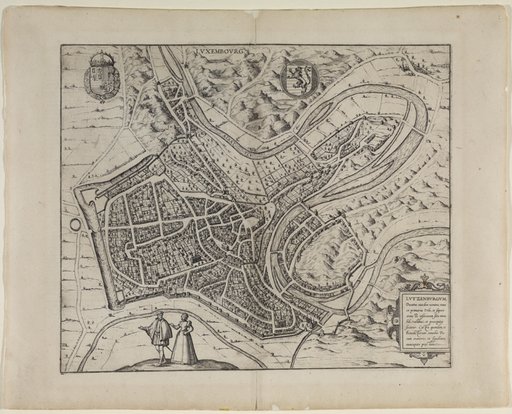
La première vue publiée de Luxembourg est le plan à vol d’oiseau de l’éditeur Georg Braun et du graveur Franz Hogenberg. Il a été publié en 1581 à Cologne dans l’Urbium praecipuarum totius mundi. Les plans à vol d’oiseau sont une forme intermédiaire entre le plan et la représentation tridimensionnelle et axonométrique des bâtiments d’une agglomération. Braun et Hogenberg ont ajouté à leur vue des maisons, des jardins, des arbres et des arbustes, qui sont probablement le fruit de leur imagination. La gravure est basée sur le plus ancien plan de Luxembourg, dessiné vers 1560 par Jacob van Deventer (1505-1575) sur ordre du roi d’Espagne.
Die früheste gedruckte Ansicht Luxemburgs ist der Vogelschauplan vom Verleger Georg Braun und dem Kupferstecher Franz Hogenberg. Er erschien 1581 in Köln im Urbium praecipuarum totius mundi. Bei den Vogelschauplänen handelt es sicht um eine Zwischenform von Plan und dreidimensionaler, axiometrischer Wiedergabe der Gebäude einer Siedlung. Braun und Hogenberg fügten ihrer Ansicht Häuser, Gärten, Bäume und Sträucher hinzu, die wahrscheinlich ihrer Fantasie entsprangen. Der Druck basiert auf dem ältesten Plan von Luxemburg, den Jacob van Deventer (1505-1575) um 1560 in königlich-spanischem Auftrag zeichnete.
The earliest pubished view of Luxembourg is the bird's-eye view by the publisher Georg Braun and the engraver Franz Hogenberg. It was published in Cologne in 1581 in Urbium praecipuarum totius mundi. The bird's-eye views are an intermediate form between a plan and a three-dimensional, axiometric representation of the buildings in a settlement. Braun and Hogenberg added houses, gardens, trees and shrubs to their view, which probably sprang from their imagination. The engraving is based on the oldest plan of Luxembourg, which Jacob van Deventer (1505-1575) drew around 1560 on behalf of the Spanish king.
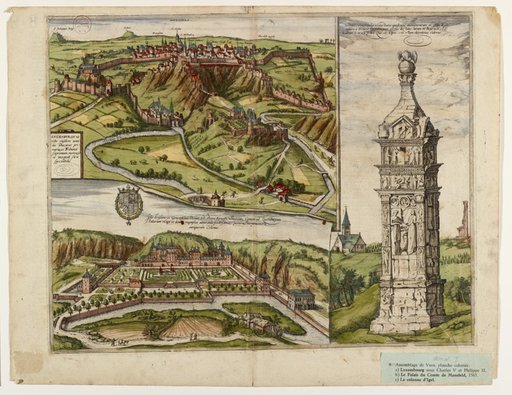
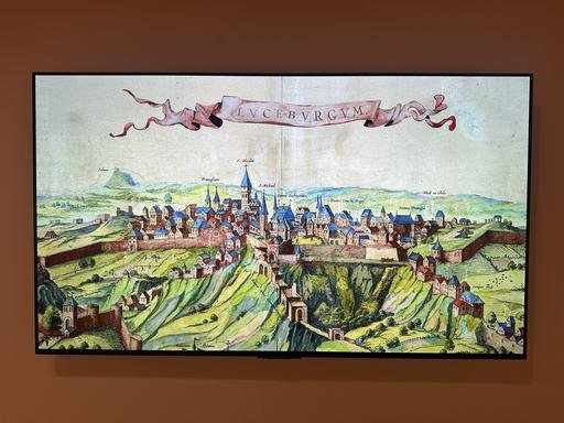
La plus ancienne vue autonome et proche de la réalité de Luxembourg est une gravure qui figure dans le cinquième volume de l’ouvrage en six tomes Civitates orbis terrarum, publié en 1596 ou 1598 par l’éditeur Georg Braun et le graveur sur cuivre Franz Hogenberg. La célèbre feuille en trois parties montre également, dans des vues séparées, la première représentation connue du château de Mansfeld, bâti à partir de 1563, ainsi que la célèbre colonne romaine d’Igel (aujourd’hui en Allemagne). La ville est représentée, vue d’en haut depuis les hauteurs de Clausen, sur un haut plateau, avec en avant-plan la crête rocheuse bien visible qui s’étend du Bock jusqu’au plateau d’Altmünster et, à gauche, dans la vallée, l’abbaye de Neumünster au Grund. La vue détaillée est accompagnée d’inscriptions indiquant les bâtiments, les chemins et les lieux environnants les plus importants.
De gauche à droite : « Franciscani » : les Franciscains ; « S. Nicolai » : l’église Saint-Nicolas qui se trouvait près de l’actuelle Chambre des Députés et qui a aujourd’hui disparu ; « S. Michaeli » : l’église Saint-Michel ; « Domus Scabinorum » : l’hôtel de Ville ; « Domus Concilii Regii » : le conseil provincial, « Domus Principis » : le palais du gouverneur ; au-dessus « Der Wech zu Arle » : la route vers Arlon.
Die älteste autonome und realitätsnahe gedruckte Ansicht von Luxemburg von Luxemburg ist im 1596 oder 1598 erschienenen 5. Band des sechsbändigen Stätebuches Civitates orbis terrarum des Verlegers Georg Braun und des Kupferstechers Franz Hogenberg enthalten. Das berühmte dreigeteilte Blatt zeigt zusätzlich, in separaten Ansichten, die erste bekannte Darstellung des Mansfeldschloss, das ab 1563 erbaut wurde, sowie das bekannte römische Grabmal aus Igel (heute in Deutschland). Die Stadt ist, von erhöhtem Standpunkt (Höhen von Clausen) aus betrachtet, auf einer Hochebene liegend dargestellt, mit dem davor prominent herausgearbeiteten Felsgrat vom Bockfels bis zum Altmünsterplateau und links davon, in Tallage, der Abtei Neumünster im Grund. die detailreiche Ansicht ist mit Beschriftungen der wichtigsten Gebäude, Wege und umliegenden Orte versehen.
Von links nach rechts : "Franciscani" : die Franziskaner; "S. Nicolai" : die St. Nikolauskirche, die sich in der Nähe der heutigen Chambre des Députés befand und heute nicht mehr existiert; die "S. Michaeli": die Michelskirche; "Domus Scabinorum": das Ratshaus; "Domus Concilii Regii": der Provinzialrat; "Domus Principis: Der Gouverneurspalast; darüber "Der Wech zu Arle": der Weg nach Arlon.
The oldest autonomous and realistic printed view of Luxembourg is contained in the fifth volume of the six-volume Civitates orbis terrarum by publisher Georg Braun and engraver Franz Hogenberg, published in 1596 or 1598. The famous three-part page also shows, in separate views, the first known depiction of Mansfeld castle (build from 1563) and the famous Roman tomb from Igel (now in Germany). The city is shown lying on a plateau, as seen from an elevated point from the heights of Clausen, with the prominent rocky ridge from the Bockfels to the Altmünsterplateau in front of it and, to the left, the Neumünster Abbey in the valley. The detailed view is provided with labels of the most important buildings, paths and surrounding places.
From left to right: ‘Franciscani’: the Franciscans; ‘S. Nicolai‘ : the Church of St. Nicholas, which was located near the present-day Chambre des Députés and no longer exists; ‘S. Michaeli’: the Church of St. Michael; ‘Domus Scabinorum’: the town hall; ‘Domus Concilii Regii’: the provincial council; ‘Domus Principis’: the governor's palace; above it ‘Der Wech zu Arle’: the way to Arlon.
Parallèlement aux vues de la ville dans la tradition Braun/Hogenberg qui mettent l’accent sur la position de la ville dans la vallée, il existe depuis le début du 17e siècle une représentation qui montre la ville comme si elle était située dans une plaine. Les hauteurs et les vallées de la ville ont été modifiées et une chaîne de montagnes, également non conforme à la réalité, insérée en arrière-plan de la ville ainsi « aplatie ». Il s’agissait probablement de montrer une vision uniforme et idéale d’une ville type, en utilisant des éléments qui se ressemblent toujours : la ville est située dans la plaine, elle est entourée de remparts avec des portes et des tours, les maisons sont serrées les unes contre les autres, un cours d’eau est représenté au milieu, une chaîne de montagnes est visible à l’arrière-plan et des arbres et des personnages sont représentés au premier plan.
Ce type de représentation n’est cependant pas complètement fictif : les bâtiments identifiables sont représentés approximativement aux bons endroits. Le seul artifice utilisé a été d’élever la ville basse au niveau de la ville haute.
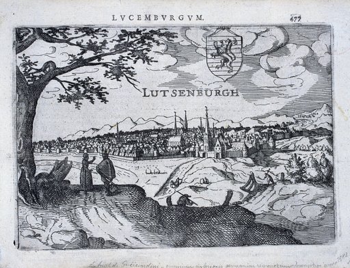
Le prototype de cette nouvelle représentation est la vue de Luxembourg dite vue de Guicciardini. En 1567, le Florentin Lodovico Guicciardini, qui vivait à Anvers, publiait pour la première fois sa Descrittione illustrée de l’ensemble des Pays-Bas. En 1613, dans une version française plus complète, on trouve pour la première fois cette vue de Luxembourg. Cette-ci montre la ville vue du sud et a été réalisée par le cartographe Petrus Montanus.
Parallel zu den Stadtansichten in der Tradition Braun/Hogenberg, die die Tallage Luxemburgs betonen, existiert seit dem frühen 17. Jahrhundert eine Darstellungsweise, welche die Stadt wie in einer Ebene liegend zeigt. Berg- und Tallage der Stadt wurden verändert und im Hintergrund der so "verflachten" Stadt eine ebenfalls nicht der Realität entsprechende Bergkette eingefügt. Vermutlich sollte so eine einheitliche und idealtypische Vision gezeigt werden, bei der immer wieder sich ähnelnde Elemente Verwendung finden: Lage in der Ebene, Stadtmauer mit Toren und Türmen, dichtgedrängte Häuser, Wasserlauf im Mittelgrund, Bergkette im Hintergrund und Bäumen und Personen im Vordergrund.
Diese Art der Wiedergabe ist aber keineswegs vollkommen fiktiv: die identifizierbaren Gebäude werden ungefähr an den richtigen Stellen gezeigt. Der Kunstgriff sei lediglich der gewesen, die Unterstadt zeichnerisch auf das Niveau der Oberstadt anzuheben.
Der Urtyp dieser veränderten Darstellungsweise ist für Luxemburg die sogenannte Guicciardini-Ansicht. Der in Antwerpen ansässige Florentiner Lodovico Giucciardini veröffentlichte 1567 erstmals seine illustrierte Descrittione der gesamten Niederlande. 1613, in einer erweiterten, französischsprachigen Fassung, findet sich erstmals die Ansicht Luxemburgs. Die Ansicht zeigt die Stadt von Süden und stammt vom Kartografen Petrus Montanus.
In parallel to the town views in the Braun/Hogenberg tradition, which emphasised Luxembourg's location in a valley, a mode of representation has existed since the early 17th century that shows the city as lying in a plain. The city's mountain and valley locations were changed and a mountain range that also did not correspond to reality was added in the background of the city that had been ‘flattened’ in this way. This was probably done to create a unified and idealised vision of a city, in which similar elements were used repeatedly: location in the plain, city wall with gates and towers, with densely packed houses, a stream in the middle ground, a mountain range in the background and trees and people in the foreground.
This type of representation is, however, not completely fictitious: the identifiable buildings are shown in approximately the right places. The only artistic licence taken was to raise the Lower Town to the level of the Upper Town in the drawing.
The archetype of this modified mode of representation for Luxembourg is the so-called Guicciardini view. Lodovico Guicciardini, a Florentine residing in Antwerp, published his illustrated Descrittione of the entire Low Countries for the first time in 1567. The view shows the city from the south and was created by the cartographer Petrus Montanus.
La vue de Braun et Hogenberg servait jusque dans la première moitié du 18e siècle de modèle à de très nombreuses autres représentations de la ville. La plus spectaculaire et la plus grande de ces copies a été publiée à Amsterdam en 1649 par Joan ou Johannes Bleau dans son Novum ac magnum theatrum urbium Belgicae Regiae. Le tome 2 de ce Stedeboek ("livre des villes"), nom néerlandais de la publication, dépeint sur 300 pages les possessions espagnoles aux Pays-Bas.
À quelques détails près, la vue est identique à celle de Braun et Hogenberg. Le musée conserve plusieurs exemplaires dans sa collection, dont des versions colorées à la main.
Die Ansicht von Braun und Hogenberg diente bis in die erste Hälfte des 18. Jahrhunderts als Vorlage für zahlreiche weitere Stadtdarstellungen. Die spektakulärste und größte dieser Kopien veröffentlichte Joan oder Johannes Bleau 1649 in Amsterdam in seinem Novum ac magnum theatrum urbium Belgicae Regiae. Band 2 dieses Stedeboek ("Städtebuch"), wie die Publikation auf Niederländisch heißt, zeigt auf 300 Seiten die spanischen Besitztümer in den Niederlanden.
Bis auf wenige Details ist die Ansicht identisch mit der von Braun und Hogenberg. Das Museum besitzt mehrere Exemplare in seiner Sammlung, darunter auch handkolorierte Versionen.
Braun and Hogenberg's view served as a model for numerous other representations of the city until the first half of the 18th century. The most spectacular and largest of these copies was published in Amsterdam in 1649 by Joan or Johannes Bleau in his Novum ac magnum theatrum urbium Belgicae Regiae. Volume 2 of this Stedeboek (‘book of cities’), the Dutch name of the publication, depicts the Spanish possessions in the Netherlands over 300 pages.
With a few details, the view is identical to that of Braun and Hogenberg. The museum has several copies in its collection, including hand-coloured versions.
Cette animation est basée sur l’œuvre de Johannes Blaeu et a été réalisée par le « Lemur Stop Motion Studio » du Lycée Ermesinde de Mersch.
Liste des personnes impliquées dans le projet: Julien Losch, Luca Birgen, Jamie Duarte, Noah Balthasar, Francisco Lopes, Cassandra Eiffes, Julia Thill, Laurie Kohl, Bruno Trzeszcz, Alexandre Binsfeld, Finn Goedert, Guilhem Weirich, Tim Lecomte, Olivier Pesch, Roby Theisen.
Diese Animation basiert auf der Arbeit von Johannes Blaeu und wurde umgesetzt von „Lemur Stop Motion Studio“ vom Lycée Ermesinde de Mersch.
Beiligte Personen: Julien Losch, Luca Birgen, Jamie Duarte, Noah Balthasar, Francisco Lopes, Cassandra Eiffes, Julia Thill, Laurie Kohl, Bruno Trzeszcz, Alexandre Binsfeld, Finn Goedert, Guilhem Weirich, Tim Lecomte, Olivier Pesch, Roby Theisen.
This animation is based on the work by Johannes Blaeu and was produced by 'Lemur Stop Motion Studio' of Lycée Ermesinde de Mersch.
The contributors to the animation project: Julien Losch, Luca Birgen, Jamie Duarte, Noah Balthasar, Francisco Lopes, Cassandra Eiffes, Julia Thill, Laurie Kohl, Bruno Trzeszcz, Alexandre Binsfeld, Finn Goedert, Guilhem Weirich, Tim Lecomte, Olivier Pesch, Roby Theisen.
La gravure a été publiée à Paris vers 1720. Deux membres de la famille d’artistes Aveline, qui vivait à Paris sur plusieurs générations du 16e au 18e siècle, sont susceptibles d’être les auteurs du dessin : Pierre (1656-1722) et Antoine (1691-1743). Dessinateurs et graveurs, ils créaient principalement des vues de villes et des paysages de France, leur pays natal, ainsi que des ornements et des personnages de mode.
La vue d’Aveline est elle aussi inspirée de celle de Braun et Hogenberg. Elle est néanmoins fortement modifiée. Le trait du dessin est plus net, ce qui donne à la ville une impression accrue de puissance.
Les parties est de l’enceinte, au-dessous du St-Esprit et de Neumünster sont absentes, tout comme celle reliant la descente du Pfaffenthal au nord-ouest de la ville. Neumünster et Altmünster ne sont pas non plus représentées. Aveline semble avoir confondu chemins et rivières de la gravure de Braun/Hogenberg qu’il a utilisé comme modèle.
Die Gravur wurde um 1720 in Paris veröffentlicht. Zwei Mitglieder der Künstlerfamilie Aveline, die über mehrere Generationen vom 16. bis 18. Jh. in Paris ansässig war, kommen als Urheber des Blattes in Frage, Pierre (1656-1722) bzw. Antoine (1691-1743). Sie schufen als Zeichner und Kupferstecher zumeist Stadtansichten und Landschaften ihrer französischen Heimat, sowie Ornamente und Modefiguren.
Auch die Ansicht von Aveline ist von der von Braun und Hogenberg inspiriert. Sie ist jedoch stark verändert. Der Strich der Zeichnung ist schärfer, was der Stadt einen erhöhten Eindruck von Macht verleiht.
Die östlichen Teile der Stadtmauer unterhalb des Heiliggeist-Plateau und Neumünster fehlen ebenso wie die Verbindung zwischen dem Weg zum Pfaffenthal und dem Nordwesten der Stadt. Auch Neumünster und Altmünster sind nicht dargestellt. Aveline scheint die Wege und Flüsse auf der Gravur von Braun/Hogenberg, die er als Vorlage verwendet, verwechselt zu haben.
The engraving was published in Paris around 1720. Two members of the Aveline family of artists, who lived in Paris over several generations from the 16th to the 18th century, are likely to be the authors of the drawing: Pierre (1656-1722) and Antoine (1691-1743). Draughtsmen and engravers, they mainly created views of towns and landscapes of France, their native country, as well as ornaments and fashion figures.
The view of Aveline is also inspired by that of Braun and Hogenberg. It is nevertheless strongly modified. The line of the drawing is sharper, which gives the town an increased impression of power.
The eastern parts of the city walls, below the St-Esprit and Neumünster are absent, as is the section connecting the Pfaffenthal descent to the north-west of the city. Neumünster and Altmünster are also not represented. Aveline seems to have confused the paths and rivers in the Braun/Hogenberg engraving that he uses as a model.
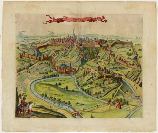
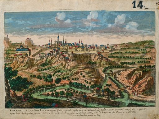
La première vue « panoramique » de la ville de Luxembourg, très importante et reprise à plusieurs reprises, a été publiée en 1654 dans la Topographia Germaniae commencée en 1642 par Matthäus Merian l’Ancien (1593-1650) et poursuivie après sa mort par ses fils Merian le Jeune et Caspar.
La représentation ressemble à celle de Guicciardini, elle montre également la ville vue du sud, mais elle est beaucoup moins « condensée » et nettement plus détaillée : les remparts et les bâtiments remarquables semblent beaucoup plus proches de la réalité, et les maisons d’habitation qui s’intercalent entre eux ne sont pas insérées comme « éléments de remplissage » comme chez Guicciardini, mais semblent correspondre à des rues réellement existantes.
Die erste, sehr bedeutende und mehrfach übernommene "panoramische" Ansicht der Stadt Luxemburg wird 1654 in der von Matthäus Merian dem Älteren (1593-1650) 1642 begonnenen und nach seinem Tod durch seine Söhne Merian dem Jüngeren und Caspar weitergeführten Topographia Germaniae veröffentlicht.
Die Darstellung ähnelt derjenigen Guicciardini, zeigt ebenfalls die Stadt von Süden her, ist jedoch weit weniger "gedrängt" und deutlich detailreicher: Stadtmauer und herausragende Gebäude erscheinen sehr viel realitätsnäher, und die dazwischenliegenden Wohnhäuser sind nicht wie bei Guicciardini als "Füllstoff" eingefügt, sondern scheinen tatsächlich vorhandenen Straßenzügen zu entsprechen.
The first very significant and widely used ‘panoramic’ view of Luxembourg City was published in 1654 in Matthäus Merian the Elder's (1593-1650) Topographia Germaniae, which he began in 1642 and which was continued after his death by his sons Matthäus the Younger and Caspar.
The illustration is similar to Guicciardini's, also showing the city from the south, but it is far less ‘compressed’ and considerably more detailed: the city wall and prominent buildings appear much more realistic, and the residential buildings in between are not inserted as ‘filler’ as they are in Guicciardini's illustration, but actually appear to correspond to existing streets.
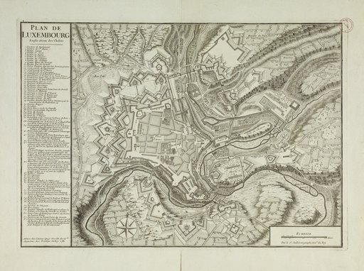
Le plan de Bernard-Hyacinthe Jaillot, graveur et éditeur à Paris, a connu plusieurs rééditions. À l’époque de sa première publication en 1735, il était très actuel. Mis à jour six ans plus tard, sur base de nouveaux levés des ingénieurs géographes, il a largement été diffusé dans les cartothèques militaires et civiles. Sur la version de 1781 figurent les forts Charles (n° 42) et Rheinsheim (n° 49), construits entre 1730 et 1733, ainsi que les nouvelles fortifications reliant ces deux forts sur le front nord-ouest. L’église Saint-Nicolas y est également représentée, alors qu’elle a été démolie en 1778, trois ans avant l’édition de ce plan.
Der Plan von Bernard-Hyacinthe Jaillot, Kupferstecher und Herausgeber in Paris, wurde mehrmals neu aufgelegt. Zum Zeitpunkt seiner ersten Veröffentlichung 1735 war er sehr aktuell. Sechs Jahre später wurde er auf Grundlage neuer Zeichnungen von Geografen aktualisiert und fand in militärischen und zivilen Kartensammlungen weite Verbreitung. In der Version von 1781 sind Fort Charles (Nr. 42) und Fort Rheinsheim (Nr. 49) zu sehen, die zwischen 1730 und 1733 errichtet wurden, sowie neue Befestigungen, welche diese beiden Forts an der Nordwest-Front miteinander verbanden. Die Kirche St. Nikolaus ist hier ebenfalls dargestellt, obwohl sie 1778, drei Jahre vor Herausgabe dieses Plans, abgerissen wurde.
The plan by Bernard-Hyacinthe Jaillot, engraver and publisher in Paris, has gone through several editions. It was very topical when first published in 1735. Updated six years later, on the basis of new surveys by geographer engineers, it was distributed widely among military and civilian map libraries. The 1781 version shows Fort Charles (n° 42) and Fort Rheinsheim (n° 49), built between 1730 and 1733, as well as the new fortifications that connect these two forts on the north-west front. The Church of Saint Nicholas is also depicted, although it was demolished in 1778, three years before the publication of this plan.
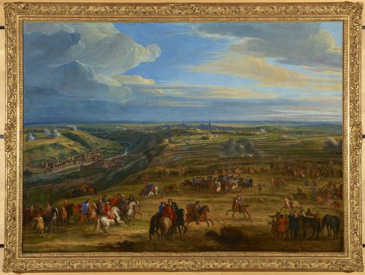
Le tableau de Jean-Baptiste Martin est une copie d’un autre d’Adam Frans Van der Meulen pour le château de Marly. Adam Frans van der Meulen a reçu une formation de peintre de bataille avant d’être chargé par Louis XIV de peindre, sous le titre de Conquêtes du Roi, les batailles les plus importantes du Roi Soleil. Jean-Baptiste Martin était chargé, après la mort de Van der Meulen, d’achever le travail du maître.
Le tableau montre la ville vue du nord, à partir du plateau de Limpertsberg. Œuvre de propagande, le tableau de Jean-Baptiste Martin tout comme celui de Van der Meulen ne montre pas les destructions que les Français ont fait subir à la ville.
En 1684 la forteresse de Luxembourg a été assiégée par les armées de Louis XIV sous la conduite de Vauban et du maréchal de Créquy. Dès le 29 avril, les assiégeants commencent à creuser une ligne de circonvallation et à mettre en place les batteries. Le 8 mai la tranchée d’attaque principale est ouverte. Le 10 mai les défenseurs espagnols abandonnent le faubourg du Pfaffenthal qui à l’époque se trouvait à l’extérieur de l’enceinte des fortifications. Avant de se retirer, les soldats espagnols mettent le feu aux maisons du Pfaffenthal et font sauter le moulin et le pont afin d’éviter que l’attaquant puisse y trouver refuge. La ville se rend finalement aux troupes françaises le 3 juin.
Das Gemälde von Jean-Baptiste Martin ist eine Kopie eines anderen Gemäldes von Adam Frans Van der Meulen für das Schloss Marly. Adam Frans van der Meulen wurde als Schlachtenmaler ausgebildet, bevor er von Ludwig XIV. beauftragt wurde, unter dem Titel Conquêtes du Roi die wichtigsten Schlachten des Sonnenkönigs zu malen. Nach dem Tod von Van der Meulen wurde Jean-Baptiste Martin beauftragt, die Arbeit des Meisters zu vollenden.
Das Gemälde zeigt die Stadt von Norden, vom Plateau von Limpertsberg aus gesehen. Das Bild von Jean-Baptiste Martin ist als Propagandawerk konzipiert und zeigt ebensowenig wie jenes von Van der Meulen die Zerstörungen, welche die Franzosen der Stadt zugefügt haben.
1684 belagerten die Armeen von Ludwig XIV. unter der Führung Vaubans und des Marschalls von Créquy die Festung Luxemburg. Am 29. April begannen die Belagerer, eine Umschanzungslinie auszuschachten und ihre Batterien in Stellung zu bringen. Am 8. Mai war die Hauptangriffsschneise geschlagen. Zwei Tage später verließen die spanischen Verteidiger den Vorort Pfaffenthal, der sich damals außerhalb der Festungsmauern befand. Vor ihrem Rückzug legten die spanischen Soldaten in den Pfaffenthaler Häusern Feuer und sprengten die Mühle und die Brücke. So wollten sie verhindern, dass der Angreifer hier einen Rückzugsort findet. Die Stadt ergab sich schließlich am 3. Juni den französischen Truppen.
The painting by Jean-Baptiste Martin is a copy of another by Adam Frans Van der Meulen for the castle of Marly. Adam Frans van der Meulen trained as a battle painter before being commissioned by Louis XIV to paint the most important battles of the Sun King under the title Conquêtes du Roi. After Van der Meulen's death, Jean-Baptiste Martin was commissioned to complete the master's work.
The painting shows the city as seen from the north, from the Limpertsberg plateau. Jean-Baptiste Martin's painting was conceived as a piece of propaganda and, like Van der Meulen's painting, does not show the destruction the French caused to the city.
In 1684, the armies of Louis XIV, under the leadership of Vauban and Marshal Créquy, besieged the fortress of Luxembourg. On 29 April, the besiegers began digging a line of entrenchments and bringing their batteries into position. On 8 May, the main line of attack was in place. Two days later, the Spanish defenders abandoned the suburb of Pfaffenthal, which was then outside the fortress walls. Before their retreat, the Spanish soldiers set fire to the houses in Pfaffenthal and blew up the mill and the bridge. In doing so, they wanted to prevent the attacker from finding a place of retreat here. The city finally surrendered to the French troops on 3 June.
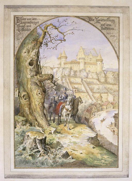
Michel Engels, né à Luxembourg-Ville, était élève puis enseignant à l’Athénée, où il a suivi les cours de Jean-Baptiste Fresez. Il a été avec Pierre Blanc (1872-1946) et André Thyes (1867-1952), entre autres, co-fondateur du Cercle artistique de Luxembourg. Il est connu pour ses dessins au crayon et à la plume représentant des scènes historiques et chrétiennes.
L’aquarelle montre une représentation imaginaire et romantique du château de Sigefroid, le premier comte à Luxembourg. Ni les sources écrites ni les découvertes archéologiques ne permettent de reconstituer une image exacte du château qui se trouvait au 10e siècle sur le Bock. Sans doute s’agissait-il d’une simple tour fortifiée avec une palissade assez primitive. Le comte lui-même et ses chevaliers sont aussi anachroniques. Néanmoins les artistes et amateurs d’histoire ont laissé libre cours à leur imagination.
Michel Engels, geboren in Luxemburg-Stadt, war Schüler und später Lehrer am Athenäum, wo er die Kurse von Jean-Baptiste Fresez besuchte. Zusammen mit Pierre Blanc (1872-1946) und André Thyes (1867-1952) war er unter anderem Mitbegründer des Cercle artistique de Luxembourg. Er ist bekannt für seine Bleistift- und Federzeichnungen, die historische und christliche Szenen darstellen.
Das Aquarell zeigt eine romantische Fantasie-Darstellung des Schlosses von Siegfried, dem ersten Grafen in Luxemburg. Weder schriftliche Quellen noch archäologische Funde ermöglichen es, ein genaues Bild von der Burg zu rekonstruieren, die sich im 10. Jahrhundert auf dem Bock befand. Wahrscheinlich handelte es sich um einen einfachen Wehrturm mit einer recht primitiven Palisade. Anachronistisch sind auch der Graf selbst und seine Ritter. Dennoch haben Künstler und Geschichtsinteressierte ihrer Fantasie freien Lauf gelassen.
Michel Engels, born in Luxembourg City, was a student and then a teacher at the Athénée, where he took classes with Jean-Baptiste Fresez. He was, with Pierre Blanc (1872-1946) and André Thyes (1867-1952), among others, co-founder of the Cercle artistique de Luxembourg. He is known for his pencil and pen drawings, depicting historical and Christian scenes.
The watercolour shows an imaginary and romantic representation of the castle of Siegfried, the first count in Luxembourg. Neither written sources nor archaeological discoveries make it possible to reconstruct an exact image of the castle that stood on the Bock in the 10th century. It was probably a simple fortified tower with a fairly primitive palisade. The count himself and his knights are also anachronistic. Nevertheless, artists and history buffs have given free rein to their imaginations.
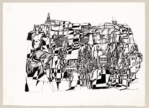
Né à Dudelange, Frantz Kinnen a fait ses études à l’École d'artisans de l’État (ancêtre du Lycée des Arts et Métiers), ensuite à Paris et Berlin. Il était un artiste polyvalent : peintre, dessinateur, verrier, sculpteur, illustrateur et caricaturiste. Il était membre du Cercle artistique de Luxembourg et il a reçu trois fois le prix Grand-Duc Adolphe. Avec Wenzel Profant, Joseph Probst et Lucien Wercollier, entre autres, il a fondé le mouvement artistique « Iconomaques » en 1954 et a exposé avec eux aux « Salons des lconomaques » en 1954 et 1959.
Sur ce dessin publié en 1963 à l’occasion des fêtes du millénaire de la ville de Luxembourg dans Luxemburg, Tausend Jahre: Kulturgeschichtliche Entwicklung der Stadt von 963-1963, l’artiste représente le mythe fondateur de la ville. Selon la légende, le comte Sigefroid s’éprit de la belle Mélusine pour laquelle il fit construire le château du Bock. Mélusine accepta d’épouser le comte à deux conditions : qu’elle ne soit jamais obligée de quitter le Bock et qu’il ne demande jamais à la voir le samedi. Des années plus tard, le comte ne tint plus et voulut savoir pourquoi son épouse désirait être seule une fois par semaine. Il regarda par le trou de la serrure et vit Mélusine se peignant les cheveux dans son bain. Il découvrit qu’à partir de sa taille, ses pieds étaient remplacés par une queue de poisson. Lorsque Mélusine s’aperçut de la trahison de son mari, elle disparut à jamais en sautant dans l’Alzette.
Der in Düdelingen geborene Frantz Kinnen studierte an der École d'artisans de l'État (die Handwerkerschule, Vorläuferin des Lycée des Arts et Métiers) und anschließend in Paris und Berlin. Er war ein vielseitiger Künstler: Maler, Zeichner, Glasmacher, Bildhauer, Illustrator und Karikaturist. Er war Mitglied des Cercle artistique de Luxembourg und erhielt dreimal den Grand-Duc Adolphe-Preis. Mit Wenzel Profant, Joseph Probst und Lucien Wercollier gründete er 1954 unter anderem die Künstlergruppe „Iconomaques“ und stellte mit ihnen 1954 und 1959 auf den „Salons des Iconomaques“ aus.
Auf dieser Zeichnung, die 1963 anlässlich der Feierlichkeiten zum Jahrtausend der Stadt Luxemburg in Luxemburg, Tausend Jahre: Kulturgeschichtliche Entwicklung der Stadt von 963-1963 veröffentlicht wurde, stellt der Künstler den Gründungsmythos der Stadt dar. Der Legende nach verliebte sich Graf Siegfried in die schöne Melusina, für die er die Burg auf dem Bock errichten ließ. Melusina willigte unter zwei Bedingungen in die Heirat mit dem Grafen ein: Sie dürfe die Burg niemals verlassen und er dürfe sie niemals samstags sehen wollen. Jahre später hielt es der Graf nicht mehr aus und wollte wissen, warum seine Frau einmal pro Woche allein sein wollte. Er schaute durch das Schlüsselloch und sah Melusina, wie sie sich in der Badewanne die Haare kämmte. Er entdeckte, dass ihre Füße ab der Taille durch einen Fischschwanz ersetzt waren. Als Melusina den Verrat ihres Mannes bemerkte, verschwand sie für immer in der Alzette.
Born in Dudelange, Frantz Kinnen studied at the École d'artisans de l'État (the forerunner of the Lycée des Arts et Métiers), then in Paris and Berlin. He was a versatile artist: painter, draughtsman, glassmaker, sculptor, illustrator and caricaturist. He was a member of the Cercle artistique de Luxembourg and was awarded the Grand-Duc Adolphe prize three times. Together with Wenzel Profant, Joseph Probst and Lucien Wercollier, among others, he founded the "Iconomaques" art movement in 1954 and exhibited with them at the "Salons des Iconomaques" in 1954 and 1959.
In this drawing, published in 1963 to mark the millennium celebrations of the city of Luxembourg in Luxemburg, Tausend Jahre: Kulturgeschichtliche Entwicklung der Stadt von 963-1963, the artist depicts the city's founding myth. According to legend, Count Siegfried fell in love with the beautiful Melusine, for whom he had Bock castle built. Melusine agreed to marry the count on two conditions: that she would never be forced to leave the Bock and that he would never ask to see her on a Saturday. Years later, the count could no longer resist and wanted to know why his wife wanted to be alone once a week. He looked through the keyhole and saw Melusine combing her hair in her bath. He discovered that from her waist down, her feet had been replaced by a fish tail. When Melusine realised her husband's betrayal, she disappeared forever into the Alzette river.
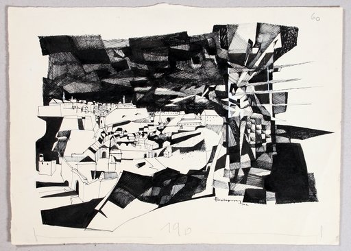
Né à Boevange, Roger Bertemes menait une double carrière en tant qu’artiste-plasticien et enseignant, et dans une moindre mesure homme de lettres. Il a étudié la gravure à Paris pendant trois mois dans l’atelier de Johnny Friedlaender (1912-1992). De retour au Luxembourg, il y a ouvert le premier atelier de gravure, où il a formé toute une génération d’artistes.
L’œuvre de Bertemes est pluridisciplinaire. Elle comprend des gravures, des aquarelles, des peintures acryliques, des peintures à l’huile, des lavis à l’encre de Chine, des collages, des dessins, des vitraux (Églises de Beggen, Betzdorf, Sanem et Limpach) et quelques sculptures ainsi que des livres d’artiste. Son œuvre picturale a évolué de la figuration vers l’abstraction. De plus son œuvre artistique est fortement liée à son activité littéraire. Auteur de livres d’artistes, de même que de textes poétiques, il a illustré plus de quarante recueils de poèmes, ainsi que plusieurs textes littéraires d’auteurs nationaux et internationaux. Son œuvre a été récompensée à de nombreuses reprises : Prix Grand-Duc Adolphe en 1960, les prix de la Biennale de la gravure de Buenos Aires en 1969 et celle de Lodz en 1989 suivie, trois années plus tard, du Prix Pierre Werner.
Le dessin de Bertemes dépeint un moment tragique de l’histoire de la ville. En 1807, la foudre a frappé une tour du Fort Verlorenkost qui servait de poudrière et de dépôt de munitions. La tour, qui a sauté, se trouvait sur une élévation et dans un endroit inhabité. Néanmoins, les ravages étaient grands dans le faubourg du Grund et ils se sont étendus jusqu’au plateau du Rham et aux quartiers de la ville haute en bordure de la vallée. L’explosion a fait une trentaine de morts et une centaine de blessés.
Roger Bertemes wurde in Boevange geboren und führte eine Doppelkarriere als bildender Künstler und Lehrer und in geringerem Maße als Literat. Er studierte drei Monate lang Radierung in Paris im Atelier von Johnny Friedlaender (1912-1992). Nach seiner Rückkehr nach Luxemburg eröffnete er dort das erste Gravurstudio, in dem er eine ganze Künstlergeneration ausbildete.
Bertemes' Werk ist multidisziplinär. Es umfasst Radierungen, Aquarelle, Acrylmalereien, Ölgemälde, Tuschezeichnungen, Collagen, Zeichnungen, Glasmalereien (Kirchen von Beggen, Betzdorf, Sanem und Limpach) und einige Skulpturen sowie Künstlerbücher. Sein bildnerisches Werk hat sich von der Figuration zur Abstraktion entwickelt. Darüber hinaus ist sein künstlerisches Schaffen eng mit seiner literarischen Tätigkeit verbunden. Als Autor von Künstlerbüchern sowie poetischen Texten hat er mehr als vierzig Gedichtbände sowie mehrere literarische Texte nationaler und internationaler Autoren illustriert. Sein Werk wurde mehrfach ausgezeichnet: 1960 mit dem Grand-Duc Adolphe-Preis, 1969 mit dem Preis der Biennale für Gravur in Buenos Aires und 1989 mit dem Preis der Biennale für Gravur in Lodz, gefolgt drei Jahre später vom Pierre-Werner-Preis.
Das Bild von Bertemes zeigt einen tragischen Moment in der Geschichte der Stadt. Im Jahr 1807 schlug ein Blitz in einen Turm des Forts Verlorenkost ein, der als Pulver- und Munitionslager diente. Der Turm, der in die Luft gesprengt wurde, befand sich auf einer Anhöhe und an einem unbewohnten Ort. Dennoch waren die Verwüstungen im Stadtteil Grund groß und erstreckten sich bis zum Rham-Plateau und zu den Stadtvierteln der Oberstadt am Rande des Tals. Die Explosion forderte etwa dreißig Todesopfer und hundert Verletzte.
Born in Boevange, Roger Bertemes led a dual career as a visual artist and teacher, and to a lesser extent as a man of letters. He studied engraving in Paris for three months in the studio of Johnny Friedlaender (1912-1992). On his return to Luxembourg, he opened the first engraving studio there, where he trained a whole generation of artists.
Bertemes' work is multidisciplinary. It includes engravings, watercolours, acrylic paintings, oil paintings, Indian ink washes, collages, drawings, stained glass windows (Churches of Beggen, Betzdorf, Sanem and Limpach) and some sculptures as well as artist's books. His pictorial work has evolved from figurative to abstract. Moreover, his artistic work is strongly linked to his literary activity. Author of artists' books as well as poetic texts, he has illustrated more than forty collections of poems, as well as several literary texts by national and international authors. His work has been recognised on numerous occasions: the Grand Duke Adolphe Prize in 1960, the prizes of the Buenos Aires Biennial of Engraving in 1969 and that of Lodz in 1989, followed three years later by the Pierre Werner Prize.
Bertemes' drawing depicts a tragic moment in the city's history. In 1807, lightning struck a tower of Fort Verlorenkost, which was used as a powder magazine and munitions depot. The tower, which had blown up, was on high ground in an uninhabited area. Nevertheless, the damage was extensive in the suburb of Grund and extended as far as the Rham plateau and the districts of the upper town on the edge of the valley. The explosion killed around thirty people and injured around a hundred.